
Witney Active Travel Corridor
Oxfordshire County Council are consulting on a collection of measures to improve cycling and walking between Madley Park and Tower Hill. The consultation is open until February 11th.
Parts of the scheme are not what we were expecting, but to be honest it was never clear what the County had submitted in its bid. What we do know is that the bid to government for the Oxfordshire schemes was not entirely successful, however funding has been found via the Oxfordshire Local Enterprise Partnership to cover the shortfall. That’s the good news.
The bad news is that the funding comes with a condition: “OxLEP have stipulated the Local Growth Funding needs to be spent or substantially committed by 31 March 2021, and as far as possible works completed. Whereas the DfT have stipulated consultation must commence before March 2021 and must be implemented by March 2022.”
With the detail design work yet to be finished, and less than 9 weeks rather than 13 months to do it, let alone implement it, we’re told any substantial changes to junctions are not possible. It sounds like an impossible task so perhaps there is some wriggle room within the accountant’s books, but modifying Fiveways roundabout to make on carriageway cycling safer is no longer part of this scheme.
This is a huge blow.
People whose journey includes Curbridge Road, Tower Hill (beyond the crossing leading to Smiths Estate), and Welch Way, will still have to cycle on the carriageway at Fiveways roundabout. Windrush Bike Project have personal experience of people being knocked off of their bikes at this roundabout – it is a known hazard.
If you have an experience to share about Fiveways roundabout we would like to hear it (admin at windrushbikeproject dot uk).
If this affects you and you want a junction at Fiveways which is safer to travel through we suggest you consider writing to your Councillor and perhaps to the Cabinet Member for Environment . Nobody seems to know why the County chose not to use any government funding in Witney given the negative impact it is having on the scheme. You can use our template letter here if it helps.
On the plus side, there are a lot of positive measures in this scheme such as area wide 20mph speed limits, signage to improve wayfinding and improvements to cycle parking.
We are in favour of the proposed 20mph speed limits: the whole of Madley Park including Woodbank; Church Lane; Langdale Gate; Church Green and down to Station Lane including The Leys; Upper High Street; Welch Way from the High Street to Woodford Way; Corn Street and all its side roads. This is a good first step.
Counting back down through the County’s consultation markers, leaving Fiveways till the end, in at number sixteen we have:
16. Woodbank to Wood Green School Entrance:
The southern half of this section is very rough and needs improving to make it smooth to ride on up to where it meets the shared path leading to Cedar Drive. Barriers currently prevent access for larger cycles and mobility scooters to the shared path alongside Madley Brook and Springfield School leading to Cedar Drive. We suggest these barriers are removed.

15. Woodbank:
We suggest the barriers at the western end of Woodbank are rearranged so larger cycles and mobility scooters can pass without having to run on the grass. A gap of 1.5m would be ideal but 1.3m would suffice.

14. Woodbank to footbridge over Madley Brook:
We support upgrading the path with lighting for shared use.
13. Park View Court to Woodbank (path to Madley Park):
We support resurfacing and upgrading path with lighting.
12. Courts Garden to Park View Court (path to Madley Park):
There is a significant hump that has appeared across the path alongside the allotments in this section and users would benefit from ‘smoothing’ this out. We support route lighting.
11. Oxford Hill to Courts Gardens (path to Madley Park):
The dogleg leading to the bridge across Madley Brook is difficult to negotiate. Negotiating the lip onto the bridge at such an acute angle has caused people to fall in wet conditions. Given that and the narrow gap leading to Oxford Hill it’s not clear why the track from Woodbank can’t be upgraded all the way to Oxford Hill to help reduce congestion along this section.
10. Oxford Hill junction with Church Lane:
We support upgrading the crossing.
9. Church Lane:
Nothing to add.
8. Langel Common from Witan Way to Church Lane:
This section of path already gets congested. We suggest increasing the width by at least 1m to make walking more relaxed. This includes widening the bridges when they reach the end of their service life.
Now we come to Witan Way roundabout which is another junction that can’t be changed in any significant way because of the restrictive timescale. The existing informal shared crossing is the only option available.
7. Witan Way Roundabout:
As well as widening and deepening the refuge island we suggest removing 4-5m of hedging next to the wall of the carpark and resurfacing it to create more space for people.
Also a cycling connection to the leisure centre is needed.
Because no significant changes can be made to the junction where Langdale Gate meets Witan Way we feel the arrangement where people cycle along Crown Lane should be allowed to continue as it has for decades.
In his book Witney History Tour, local historian Stanley C. Jenkins writes, “Until the untimely demise of the Crown Hotel, Crown Lane had provided a pedestrian link between Market Square, Langal Common and Cogges. The aperture between Keates’ shop and the Crown was exceedingly narrow, but the path was nevertheless well used by pedestrians and cyclists.”
The Crown Hotel was demolished in 1981 and Langdale Gate developed during the early ’80s.
6. Langdale Gate:
The cycle route should be signed along Crown Lane to avoid confusion about legality. It is a footpath with a history of use as a cycle route rather than a footway. We suggest the cycle route rejoins the carriageway at the entrance to Langdale Hall carpark – can the giveway lines be modified to keep it clear?
Although the pavement from the carpark to Market Square is wide, people walking and cycling are unsighted at the corner by the zebra crossing so we do not think that shared use is appropriate there.
It’s not clear how advisory cycle lanes will remain useful where there is currently a bus stop and disabled parking on the double yellow lines.
If used the width of advisory cycle lanes must meet the current standards given in LTN 1/20 to be inclusive.
There is a desire line for people crossing the road by the toilets. We suggest a zebra crossing here would help people to cross and help reduce speeds.
5. Market Square:
Nothing to add.
4. Corn Street (from Holloway Road to Market Square):
Subject to the views of residents in the Corn Street area we support the change to one-way except bus and cycle.
We support the zebra crossing by Marlborough Lane.
We are concerned that removing the build-outs will increase speeds with one-way traffic. If the build-outs are removed the bike parking in that section of Corn Street will be lost and needs replacing. Also a zebra crossing will be required at the Market Place end to allow people to cross there easily.
If the build-outs remain we suggest changing the current priorities so that buses and cycles going against the one-way flow have priority.
We are disappointed that there is not time to adequately investigate creating cycle tracks between Marlborough Lane and The Crofts and Holloway Road. The wide pavements are likely to be used for eating out and children attending Batts School would be more likely to use those tracks than an advisory cycle lane on the road.
We note that Corn Street has been closed to traffic at Market Square for the last week because of emergency sewer repairs. That should give residents a good idea of how making it one-way there will affect them.
3. Corn Street (from Five Ways roundabout to Holloway Road):
Advisory cycle lanes must meet the current standards given in LTN 1/20 to be inclusive. It is not clear how advisory cycle lanes will work with the bus stops.
Now we come to the crucial junction in this scheme, Fiveways roundabout.
The quickest and cheapest way to achieve a cycle route people will be happy to use is to reduce traffic to a tolerable level with point road closures. Adequate consultation aside, this has been proven during the first round of Emergency Active Travel schemes in many parts of the country.
Designing for cycling that is a mix of off-road and on-road with high volumes of traffic is complicated and difficult. And that takes time too.
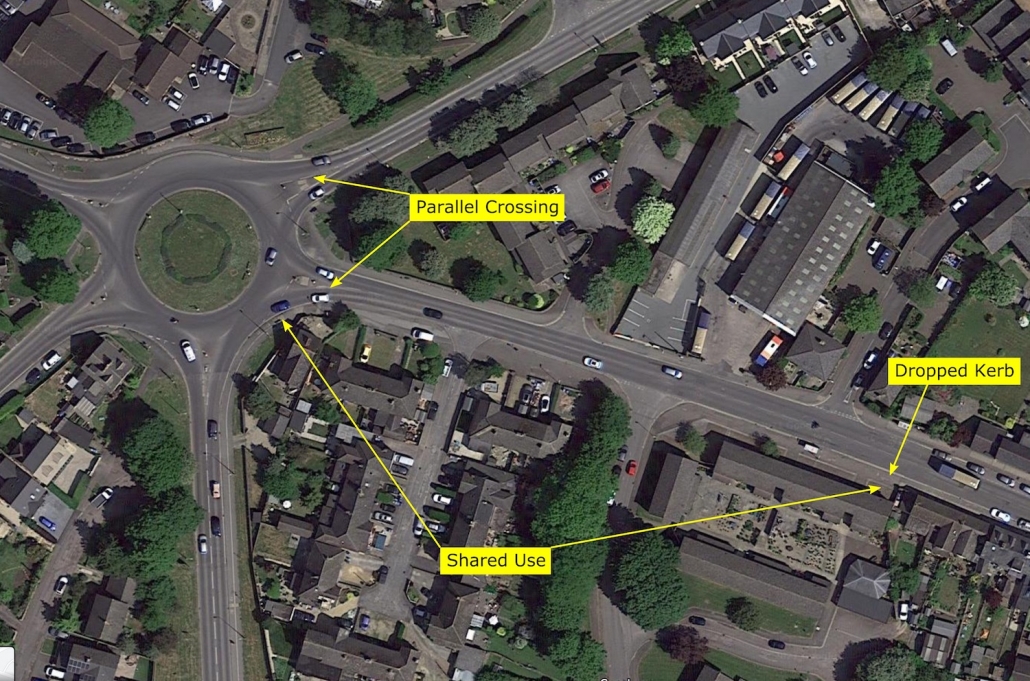
We don’t have any detailed drawings for how this part of the route will look, only the descriptions which suggest that the existing crossings on Corn Street and Welch Way will be used. We have ridden the existing crossings and we are particularly concerned about the crossing on Corn Street. To keep things short the problem revolves around point A in this diagram.

Cycling and walking differ in that walkers can turn around on the spot in a way which someone sat on a cycle cannot. Someone cycling from point A who wants to join the carriageway and continue along Corn Street cannot adequately see the traffic approaching from Welch Way because it’s approaching from behind them. A solution is to cycle along the pavement and rejoin at point B.
However, the same applies to someone who wants to continue along Ducklington Lane via the existing cycle path at point C.
We believe a solution is to move the crossing to a position where people can better see the traffic approaching when sat on a cycle facing the crossing. Moving the crossing means there is no longer room for a ‘refuge’ in the centre of the road so we suggest using a new type of zebra crossing that allows both cyclists and pedestrians to cross the road – a Parallel Crossing.

Since this is a scheme to prioritise active travel, we suggest, rather than dash to a ‘refuge’ on Welch Way, a Parallel Crossing should be installed there as well.
2. Five Ways roundabout:
The crossing on Corn Street is not suitable for cycling. The road layout and the position of the crossing mean people cycling are denied the information they need to decide if it is safe to cross. We suggest moving the crossing further from the roundabout and making it a Parallel Crossing.
We suggest improving the service to active travellers by installing a Parallel Crossing on Welch Way as well. Where possible make the approach to the crossings perpendicular to the road to improve visibility of approaching traffic.
LTN 1/20 section 10.4.12 states “Parallel crossings can be used on links and on the arms of priority-controlled and roundabout junctions.”
We suggest that the southern side of Corn Street near Fiveways is made shared use with a dropped kerb access to allow people cycling to avoid the buses parked in the bus stop awaiting a driver changeover.
1. Tower Hill:
We are concerned about how wide the pavement can be made approaching the crossing.
Cycling into town people have the choice to cycle on the road and rejoin the path at Beech Road, however, cycling uphill, with shopping, reaching the button at the far side of the stop and turning to cycle across could be a difficult manoeuvre for some.
The barriers alongside the cemetery leading to Fettiplace road need to be removed to allow access for larger cycles and mobility scooters.

One of the most positive parts of the scheme will the monitoring of travel, along with ‘activation’ initiatives to encourage people to use it. However, before we could encourage people to use all of it, we would have to be satisfied that it is objectively safe to do so.
Also the route needs to live up to its billing. Is creating some shared use pavements and widening some refuges in the middle of the road prioritising active travel? We think not.
We very much hope a way can be found to rectify the situation and get closer to the expectations of the people who the County want to use this route. Please respond to the consultation.
Extra resources:
Template letter to your local councillor: Witney Active Travel Edited
Consultation responses for your reference: Witney Active Travel Corridor Consultation Response Feb 2021

